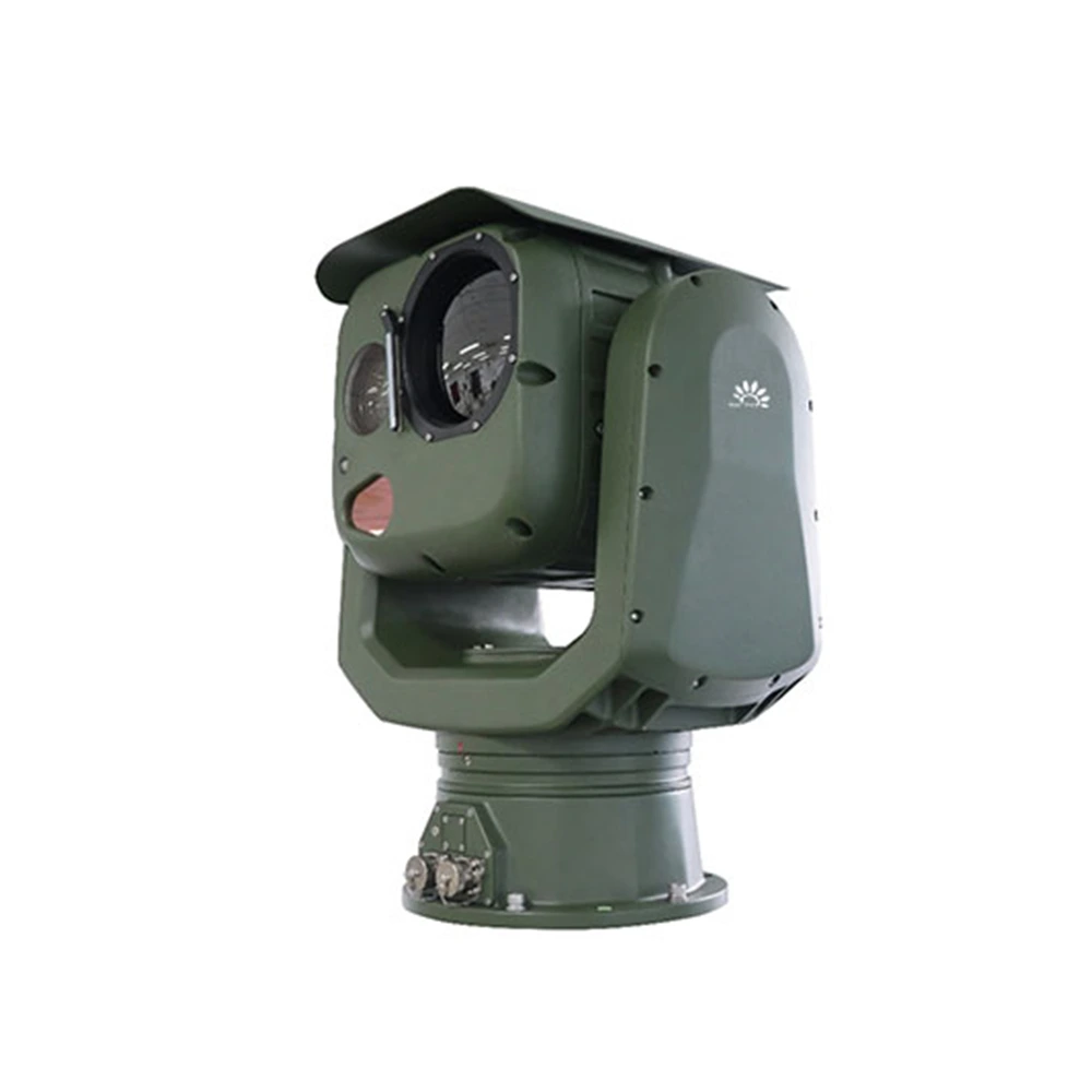

The HP-Z50 optoelectronic Pan Tilt is an integrated optoelectronic detection and tracking system designed for low-altitude security in key locations such as conference centers, office buildings, prisons, and airports. It employs a high-definition visible light camera, an uncooled thermal imager, and a multi-spectral detection module, combined with an intelligent target detection and tracking module. This enables effective detection, tracking, identification, and early warning of small to medium-sized consumer-grade rotary-wing and fixed-wing UAVs. The turntable can be used independently or in conjunction with radar equipment, passive spectrum detection equipment, and radio jamming equipment to form an automatic UAV defense system, effectively ensuring low-altitude security in key locations day and night, in all weather conditions.
Capable of supporting long-focal-length visible light cameras and large-aperture thermal imagers. Optional laser ranging, positioning and navigation, and electronic compass sensors enable ultra-long-range target observation.
Integrates high-definition visible light and uncooled thermal imaging, offering complementary advantages across multiple detection bands. Combines active and passive detection, and integrates multi-source data for fusion processing, leaving targets nowhere to hide and meeting monitoring needs in day and night, all-weather environments.
Fast turning speed, rapid start-up and shutdown, and smooth operation, facilitating the capture and tracking of fast-moving targets.
Further features to be added
High level of intelligence, supporting abnormal behavior detection such as target intrusion detection and motion detection, target classification and recognition, radar linkage, 3D zoom positioning and other functions, greatly improving the system's unmanned, automated and information-based level.
Strong environmental adaptability, high-strength aluminum alloy material, double-layer three-proof technology, IP67 protection, rainproof, dustproof, corrosionproof, and electromagnetic interference-proof, suitable for long-term use in harsh outdoor environments.
Suitable for key locations such as conference centers, office buildings, prisons, airports, etc., effectively ensuring low-altitude safety day and night, in all weather conditions.
| Model | HP-Z50-TC121023-VC4080-ZW Optical Pan Tilt |
| Effect Distance | Under atmospheric visibility conditions ≥20km, humidity ≤50%RH, and temperature difference >6K, the maximum visible light detection range for a 0.3m*0.3m UAV target is 6000m, and the thermal imaging detection range is ≥2500m. |
| Infrared thermal imaging | 1. Detector: Uncooled vanadium oxide (VOx) infrared focal plane array 2. Spectral range: 8μm~14μm 3. Resolution: 640×512 4. NETD: Better than 30mK 5. Lens focal length: 23~230mm, 10x continuous zoom lens 6. Lens control: Motorized zoom, manual/autofocus 7. Supports high-light protection function |
| High definition Visible light |
1. Sensor: 1/1.8″ target-surface starlight-level CMOS, ICR color-to-black and white 2. Resolution: 2688×1520, 4 million pixels 3. Illuminance: Color: 0.002 Lux; Black and White: 0.0002 Lux 4. Encoding Format: H.264/H.265/MJPEG 5. Image Enhancement: Supports wide dynamic range, strong light suppression, electronic image stabilization, 3D digital noise reduction, automatic white balance, etc. 6. 12.5~775mm high-definition power zoom lens, 60x optical zoom 7. Fog Penetration: Supports both photoelectric and electronic fog penetration. |
| Servo PTZ | 1. Structure: Spherical, two-axis, two-frame 2. Viewing Window: Two viewing windows, capable of simultaneously accommodating two different wavelength sensors 3. Horizontal Range: N×360° continuous rotation, mechanically lockable after power failure 4. Pitch Range: -90°~+90°, with soft limit function, programmable 5. Rotation Speed: Horizontal 0.01°~120°/s, Pitch 0.01°~90°/s, maximum horizontal speed ≥200°/s 6. Acceleration: Horizontal 120°/s², Pitch 120°/s² 7. Speed Adaptive: Intelligent inductive speed control, supports lens focal length speed adaptive function 8. Drive Method: High-torque rare-earth permanent magnet synchronous motor direct drive, high-speed start/stop 9. Positioning Accuracy: Better than 0.005° |
| Tracking function |
1. Tracking Method: Front-end embedded hardware tracking 2. Tracking Mode: Manual and automatic tracking, supports radar linkage 3. Video Switching: Digital high-definition visible light/digital infrared video switching tracking 4. Tracking Functions: Built-in multiple tracking algorithms, supporting multi-target detection, automatic acquisition, automatic zoom during tracking, real-time target trajectory display, anti-brief occlusion, etc.; manual and automatic tracking, supports radar linkage tracking; supports target recognition during tracking; supports recognition-based tracking; supports adaptive gate for air tracking, and the tracking frame size can adapt to the target size. 5. Tracking Display: Features a target magnification display with adjustable position, supporting 2x, 4x, and 8x target magnification. |
| Intelligent Analysis | 1. Built-in 16TOPs computing power processor 2. Implementation method: Front-end embedded intelligent analysis module 3. Abnormal behavior detection: Supports target recognition; supports area intrusion detection, boundary intrusion detection, motion detection, etc. 4. UAV target recognition algorithm, with an improved small target enhancement layer for UAVs, reliable training for low light, weather changes (rain, snow, fog), and cluttered backgrounds (urban buildings), dedicated algorithm models such as infrared image fusion, dynamic perception adjustment, cross-view tracking of high-speed maneuvers, and adaptive feature fusion, as well as anti-interference enhancement technologies (multimodal fusion, dynamic background modeling, rotor feature recognition model training). It can track high-speed targets at 125 km/h with a jitter error of 12 pixels and a range of 3 km under nighttime line-of-sight conditions. The algorithm detects drone targets externally with a tracking delay of 180ms. It can perform self-supervised learning to reduce label dependence and achieve optimized algorithms for collaborative intelligent tracking of visual-wireless signal directional interference. 5. False Alarm Rate: Bird false alarm rate reduced to 9%, cloud movement false alarm rate reduced to 4%. 6. Training Load of Recognition Algorithm: 60,000 labeled samples, 35,000 infrared or visible light fusion images for training, 120,000 interaction steps. 7. Data Quality: The data processed by the algorithm is highly consistent with objective facts, with minimal error, ensuring accurate decision-making. All necessary information is collected without missing data, providing a complete perspective for global analysis. Data formats are unified across different systems to avoid contradictory information interfering with decision-making. Data is updated rapidly, and business decisions are based on the latest information. |
| Environmental adaptability | 1. Operating temperature: -40℃~60℃, Storage temperature: -45℃~+70℃ 2. Humidity: 95%RH 3. Lightning surge protection: Power supply 4000V, communication signal 2000V 4. Salt spray protection: pH value 6.5~7.2, can still operate normally after 96 hours of continuous salt spray test 5. Vibration: Meets the requirements for highway truck transportation environment in GJB150A.16 6. Protection rating: IP67 |
| Other | 1. Network Interface: One 100M/1000M auto-sensing Ethernet port 2. Network Protocols: Supports TCP/IP, HTTP, RTP, RTSP, PPPoE, DNS, FTP; supports ONVIF2.0, GB28181, and other network protocols; 3. Power Supply: AC220V±20%, 50Hz 4. Total Power Consumption: Maximum ≤600W, Stable ≤150W 5. Dimensions: Ф565mm×H880mm 6. Total Weight: ≤110kg |
| Backend software | 1. Client: Includes a dedicated tracking client, supporting radar and optoelectronic device access for real-time device status monitoring. 2. Situation Display: Supports dynamic display of target points and tracks reported by radar; supports simultaneous playback of radar target tracks and optoelectronic video recordings. 3. Auxiliary Tools: Supports distance, area, and angle measurements; supports static calibration azimuth calculation; supports radar and optoelectronic four-quadrant auxiliary calibration. 4. Gimbal Control: Supports eight-directional gimbal control; supports WASD key control for up, down, left, and right movement; supports zoom and focus lens control; supports horizontal angle positioning, pitch angle positioning, and field of view angle positioning. 5. Electronic Map: Supports electronic maps and radar/optoelectronic real latitude and longitude map landing points; supports online and offline 2D maps. 6. Remote Configuration: Supports remote power on/off and restart of optoelectronic devices, visible light thermal imaging power on/off, and remote camera parameter settings. 7. Multi-Screen Display: Supports split-screen display of video preview, electronic map, video monitoring, video playback, and information management; supports multiple video preview interfaces displayed in split-screen mode. |
1. Understand Your Product Requirements
2. Evaluate Industry Experience
3. Review Successful Case Studies
4. Consider After-Sales Service
PTZ devices are typically equipped with various devices, including optical lenses (such as infrared cameras), acoustic sensors, radar, antennas, lighting searchlights, etc.
We are the direct factory, of course,it's competitive, quality/price and services are guaranteed.
Yes. Welcome at any time.
Copyright © 2026 by KONWER Technology Co., Ltd. All Rights Reserved